
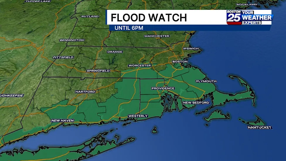
A significant weather system tracking across southern New England has prompted regional meteorologists and emergency management officials to issue an urgent flood watch for multiple communities throughout Massachusetts. Heavy rain clusters advancing across the area are threatening to trigger sudden flash flooding, creating potentially hazardous traveling conditions on roadways and in low-lying sectors throughout Sunday afternoon and evening.
The active flood watch encompasses a wide geographic swath of central, eastern, and coastal Massachusetts, officially covering Bristol, Plymouth, Barnstable, Dukes, Nantucket, Worcester, Norfolk, and Suffolk counties. Forecasters have established that the regional weather advisory will remain in effect through 6:00 p.m. on Sunday, urging residents across these major population centers and island communities to remain vigilant and prepare for rapid weather changes.
In response to the deteriorating atmospheric setup, the Boston 25 Weather Team has placed the region under an official severe weather alert. Meteorologists are closely monitoring the incoming precipitation shield and convective activity, both of which pose localized water hazards and severe drainage challenges across extensive portions of southern New England.
According to Boston 25 meteorologist A.J. Mastrangelo, the primary cluster of heavy precipitation was modeled to advance steadily into southeastern Massachusetts during the late morning hours. The progression of these concentrated rain bands brings heightened flooding concerns for coastal and inland communities situated directly in the path of the incoming storm front.
Mastrangelo highlighted that the most vulnerable areas remain those positioned along and south of the Massachusetts Turnpike. Within this critical transit and residential corridor, the flood watch is set to maintain its active status until the designated 6:00 p.m. expiration timeframe, requiring continuous situational awareness from weekend commuters, travelers, and emergency response personnel.
Forecasters explain that the broader storm pattern consists of general showers interspersed with embedded thunderstorms. These convective storm cells are capable of generating highly concentrated, narrow corridors of torrential downpours that can quickly saturate ground surfaces and overwhelm local drainage systems in a remarkably short span of time.
Across the wider affected zone in Massachusetts, baseline precipitation totals are anticipated to reach between half an inch and two inches of rain. While these widespread baseline totals can typically be handled by standard municipal infrastructure, the uneven structure of the storm system creates localized risks of much heavier accumulation in areas caught under persistent downpours.
Meteorologists have warned that the localized, narrow bands of embedded storms could deliver intense rainfall volumes ranging from two to four inches within a condensed three-hour window. Such rapid accumulation rates severely reduce the capacity of natural soil absorption and can quickly cause water to back up onto major highways, secondary streets, and low-lying residential areas.
The National Weather Service noted that although a degree of uncertainty remains regarding exactly where these tight bands of heavier rain will establish themselves, the threat of localized flash flooding remains a serious concern. The unpredictability of these narrow precipitation corridors makes comprehensive preparedness necessary across all counties included within the advisory.
Federal forecasters with the National Weather Service emphasized that flash flooding risks are especially acute if these high-volume bands develop or stall directly over vulnerable urban centers. Highly developed metropolitan areas with dense concentrations of impervious pavement and aging storm drains are particularly susceptible to rapid, dangerous surface water accumulation during torrential downpours.
As storm conditions unfold across the state, public safety officials are advising residents to utilize state tracking tools to monitor potential utility disruptions. The Massachusetts Emergency Management Agency maintains a public real-time power outage tracking platform that displays active electrical outages across the state, regional territories, and local neighborhoods, while providing status updates and restoration timelines directly from utility companies.
In addition to the power outage platform, the Massachusetts Emergency Management Agency provides live interactive weather radar displays and forecasting instruments. These digital mapping resources are designed to help community members track real-time precipitation movements and evolving storm cells directly as they traverse the Commonwealth throughout the day.
Community members seeking additional non-emergency guidance, state resources, or assistance during the severe weather event are encouraged to access the Mass211 system. Furthermore, federal coordination channels remain available through the Federal Emergency Management Agency to support broader regional safety and emergency management operations if conditions worsen.
Continuous meteorological monitoring and official updates are being coordinated through National Weather Service forecast offices in both Boston, Massachusetts, and Albany, New York, alongside continuous social media and broadcast reporting from Boston 25 weather specialists. Residents across southern and eastern Massachusetts are urged to stay informed and monitor local alerts until all flood advisories expire on Sunday evening.


(0)