
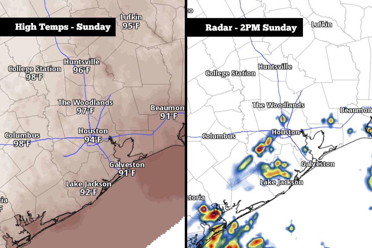
Residents across the greater Houston metropolitan area are preparing for a return of unsettled weather on Sunday, as incoming Gulf moisture triggers the development of scattered showers and thunderstorms. While the incoming precipitation will offer brief localized cooling, the region remains trapped in an unseasonably warm and humid pattern that is expected to dominate conditions well into the coming week.
The unsettled shift follows a stark meteorological transition across Southeast Texas over the late summer months. Although the area experienced an exceptionally wet spring and early summer, the atmosphere shifted drastically around mid-July into a prolonged dry spell. Between July 15 and mid-September, Houston recorded a mere 2.55 inches of total precipitation, representing approximately 30 percent of the typical rainfall expected during that time frame.
Sunday began on an unusually mild and muggy note across the regional landscape. Morning low temperatures across the Houston metropolitan area hovered near 80 degrees, establishing an uncharacteristically warm baseline. In typical years, mid-September low temperatures generally settle closer to 72 degrees, making the morning readings significantly higher than regional averages.
Atmospheric heating is expected to escalate rapidly as the day advances. Surface temperatures are projected to climb to 90 degrees as early as 11 a.m. before reaching peak afternoon highs around 94 degrees. These elevated temperatures will interact with deep moisture flowing northward from the Gulf of Mexico, creating an oppressive outdoor environment for local residents throughout the afternoon.
The intense humidity will drive heat index values—frequently referred to as the "feels-like" temperature—well above the actual thermometer readings. Peak afternoon heat indices are forecast to reach between 103 and 105 degrees across Southeast Texas. Weather analysts caution that the combination of intense late-summer sunshine and heavy air will pose elevated thermal discomfort during peak daylight hours.
Convective activity is scheduled to peak alongside maximum daytime heating. Overall precipitation chances across the metropolitan area are slated between 30 and 40 percent, with the most favorable timeframe for storm development concentrated between noon and 4 p.m. Because these storm cells rely on daytime solar energy, precipitation probabilities will drop rapidly to under 20 percent by the early evening hours.
Meteorologists emphasize that the rainfall will remain scattered in distribution, meaning that large portions of the metro area may miss out entirely on measurable rain. However, the localized cells that do materialize have the potential to produce isolated heavy downpours accompanied by localized strong wind gusts as they track across the region.
Overall precipitation accumulations are projected to remain relatively light for the vast majority of Southeast Texas neighborhoods. Most communities receiving rainfall can expect less than a quarter of an inch of accumulation. Even in spots where isolated downpours linger, totals are only anticipated to reach around a half-inch or slightly higher, keeping the threat of regional flooding at an exceptionally low level.
The underlying atmospheric pattern responsible for Sunday’s warmth will persist into the beginning of the standard workweek. A stubborn, stalled high-pressure system anchored just east of the area will continue to dictate local weather from Monday through Wednesday, maintaining a steady pipeline of muggy air and above-average heat.
During the Monday-through-Wednesday period, Houston’s daily high temperatures will consistently settle between 92 and 94 degrees. While such temperatures are not entirely unprecedented for late summer, the presence of abnormally high humidity for mid-September will compound the thermal strain, pushing daily heat index values up to an oppressive 105 to 107 degrees each afternoon.
Rain opportunities during the first half of the workweek will remain minimal and fleeting. Regional precipitation chances will stay capped at a modest 20 to 30 percent each day from Monday through Wednesday. Any storms that manage to form in the afternoon heat will be largely isolated and brief, offering little widespread relief from the ongoing dryness.
A minor transition in the broader synoptic pattern is anticipated toward the conclusion of the week. By Thursday and Friday, the eastern high-pressure system will begin to weaken slightly, allowing afternoon high temperatures in Houston to ease downward into the lower 90s, with anticipated peaks of 91 to 92 degrees. Rain chances are also projected to increase marginally as the upper-level ridging relaxes.
Looking toward next weekend, extended forecast models indicate that an approaching cold front will attempt to push into the state of Texas. However, present guidance indicates that this front will likely lose momentum and stall out before pushing entirely through the Houston metropolitan area. As a result, the boundary is not expected to trigger a significant drop in temperatures, though scattered storm chances will remain in the forecast as the front lingers nearby.


(0)