
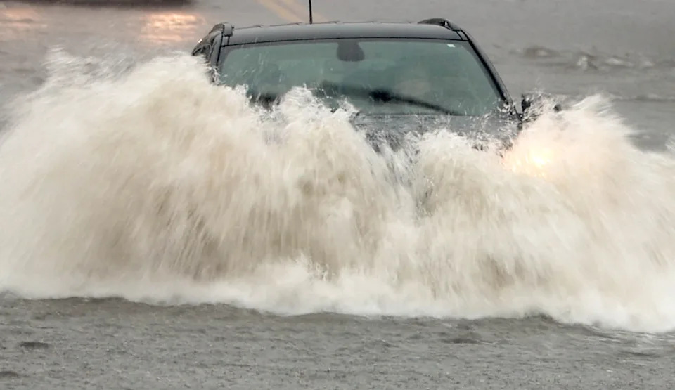
A powerful storm system swept across southern New England on Sunday, unleashing intense downpours that inundated roadways, paralyzed transit networks, and created hazardous conditions for communities across Massachusetts and Connecticut. The heavy precipitation transformed low-lying streets into turbulent waterways within a matter of hours, stranding vehicles and prompting immediate emergency advisories from local authorities and regional weather forecasters.
The severe weather event delivered a concentrated deluge that rapidly overwhelmed stormwater infrastructure across multiple municipalities. Downpours associated with the passing system quickly accumulated on thoroughfares, creating impassable routes in coastal, suburban, and urban communities alike. Emergency services and local officials found themselves managing numerous reports of stalled automobiles and disrupted travel lanes throughout the daytime hours.
In response to the rapid accumulation of surface water, the National Weather Service issued flash flood warnings for multiple areas throughout the region, placing a particular emphasis on vulnerable sectors in southeastern Massachusetts. Forecasters cautioned that the intense rate of rainfall presented an immediate threat to travel and property, requiring rapid adjustments from both municipal agencies and everyday motorists attempting to navigate the storm.
Meteorological data indicated that localized rainfall totals could reach as high as four inches before the storm system fully moved out of the area by late afternoon. The sheer volume of rain arriving over a condensed timeframe left little opportunity for natural drainage systems or urban culverts to channel the runoff effectively, resulting in swift poolings of water along highway corridors, residential neighborhoods, and vital transit junctions.
Communities across southeastern Massachusetts bore a substantial portion of the storm's impact. Local authorities received a steady stream of reports detailing severely flooded roadways and abandoned vehicles from towns and cities including Fall River, New Bedford, Plymouth, Wareham, and Vineyard Haven. In each of these jurisdictions, responders worked to manage hazardous conditions where rising water levels made normal vehicular passage impossible.
The severity of the deluge was especially evident in Fall River, where recorded video footage illustrated the alarming extent of the flooding. Streetscapes were captured functioning more like active rivers than paved roads, with floodwaters rising around vehicles as drivers struggled to maintain traction and maneuver through submerged corridors. In several instances, motor vehicles were left disabled as rising waters breached engine compartments.
As conditions deteriorated, meteorologists and public safety personnel reiterated critical guidance regarding the perils of driving through standing or moving floodwaters. The National Weather Service repeated its long-standing safety advisory, urging travelers to "turn around, don't drown." Officials underscored that drivers frequently miscalculate the depth of standing water or underestimate the power of moving currents, leading to catastrophic outcomes.
The National Weather Service emphasized that the vast majority of flood-related fatalities occur when individuals are inside their motor vehicles. Flowing water can quickly compromise vehicle control, while deeper accumulations can float heavy automobiles or sweep them entirely off the roadway. For this reason, emergency management teams consistently urged drivers to treat any water-covered street as a completely impassable hazard.
The severe disruptions caused by Sunday’s storm were not restricted to Massachusetts, as neighboring southern Connecticut experienced similarly intense weather impacts. Heavy rain bands pushed across the state line, delivering rapid flash flooding that inundated local streets, overwhelmed municipal drainage systems, and compromised crucial intercity transportation corridors throughout the area.
Among the most significant regional infrastructure disruptions was the complete suspension of Amtrak passenger rail service in New Haven, Connecticut. Rail officials determined that severe localized flooding had directly affected track conditions, creating substantial safety risks that made regular train operations across the corridor impossible until water levels receded and inspections could be conducted.
Connecticut Governor Ned Lamont addressed the mounting transportation crisis directly through a public statement on Facebook, confirming that state emergency teams were actively monitoring flash flood conditions statewide. Lamont noted that transit services in New Haven were facing severe interruptions and appealed directly to the public to exercise maximum vigilance amidst the deteriorating weather.
"Flash flooding is impacting several areas across Connecticut, including transit service in New Haven. We are closely monitoring the situation," Governor Lamont wrote in his advisory to residents. He further cautioned the public to remain alert, exercise extreme caution during necessary travel, steer clear of flooded roadways, and strictly avoid attempting to drive through standing water under any circumstances.
Transportation experts note that sudden flash floods pose complex challenges for regional networks, as rail corridors, highway underpasses, and coastal routes are especially prone to swift inundation during high-intensity storm cells. The simultaneous breakdown of road and rail links across southern New England underscored the vulnerability of transit systems when faced with concentrated downpours exceeding several inches over brief intervals.
Relief from the hazardous conditions, however, was anticipated by the end of the day. Forecasters with the National Weather Service indicated that the heaviest rain bands would gradually taper off by late Sunday afternoon as the storm system migrated further away from southern New England, bringing an end to the active flash flooding threat.
Following the departure of the storm, meteorologists forecast a noticeable shift in the regional atmospheric pattern, ushering in cooler and substantially drier air to start the new workweek. The incoming dry front is expected to provide municipal crews and emergency personnel with favorable conditions to clear remaining roadway standing water, complete railway track assessments, and allow regular transit schedules to resume safely.







(0)